|
|
Post by Snowman99 on Jan 13, 2022 14:08:54 GMT -6
18 z nam is gonna be worse than 12 z
|
|
|
|
Post by ajd446 on Jan 13, 2022 14:10:29 GMT -6
I would not read too much into the nam yet. If it still shows that tomorrow morning than sure it may be on to something
|
|
mccarthb
Junior Forecaster
  O'Fallon, MO - Outer Road near border of Dardenne Prarie
Posts: 443 
|
Post by mccarthb on Jan 13, 2022 14:10:32 GMT -6
EC is a bit further W/SW than the GFS/NAM blend...split the middle and the Metro is sitting in a nice spot. 2-4" looks pretty solid...some areas might get closer to 6" if the Fgen band develops and parks itself. By the time anyone gets up to measure it 6" will compact back to 4" there will be some quick settling and some melting from below too. Very "March" like system. You should know that we don't sleep during storms like this when it whisks through in the middle of the night  . Night Owl cameras pointing to a ruler in the ideal spot are helpful as well in case I do pass out (which tends to be occurring more frequently with age)  |
|
|
|
Post by ajd446 on Jan 13, 2022 14:19:15 GMT -6
Actually nam looks good
|
|
mccarthb
Junior Forecaster
  O'Fallon, MO - Outer Road near border of Dardenne Prarie
Posts: 443 
|
Post by mccarthb on Jan 13, 2022 14:26:25 GMT -6
By the time anyone gets up to measure it 6" will compact back to 4" there will be some quick settling and some melting from below too. Very "March" like system. You're probably right unless the pivot works out better for us which looks unlikely so far. When was the last time a storm like this occurred where a SE pivot swiveled NW for a wrap-around event in the metro? |
|
|
|
Post by BRTNWXMAN on Jan 13, 2022 14:29:16 GMT -6
18z NAM shifted a bit east overall...has a big chunk of dry air around 850mb across central MO but still has the Fgen band along the river to a lesser extent and really tries to get the TROWAL going across the S counties Sat AM.
|
|
|
|
Post by addicted2wx - Villa Ridge, Mo on Jan 13, 2022 14:29:37 GMT -6
Somehow the 18z NAM found a way to go Kaboom.
|
|
|
|
Post by BRTNWXMAN on Jan 13, 2022 14:33:29 GMT -6
You're probably right unless the pivot works out better for us which looks unlikely so far. When was the last time a storm like this occurred where a SE pivot swiveled NW for a wrap-around event in the metro? It seems like there was a storm several years back that dug strongly down the Central Plains towards the Red River Valley and managed to cut off and pivot soon enough for us to get the goods or maybe the S counties got it...can't remember. I do remember a similar wrapped up clipper or two like this one in 2010...but this one is a bit of an odd duck really. The due S or even slight SSW jog before turning the corner is something I'm not sure I've seen before. |
|
|
|
Post by mchafin on Jan 13, 2022 14:35:12 GMT -6
Hour 36 of the 18z NAM. Science is just mean sometimes.
|
|
|
|
Post by BRTNWXMAN on Jan 13, 2022 14:36:32 GMT -6
Somehow the 18z NAM found a way to go Kaboom. It's QPF depiction still looks nice with the Fgen band along the river. The mid-level low track definitely came a bit east and less elongated which could be a substantial trend. |
|
|
|
Post by BRTNWXMAN on Jan 13, 2022 14:39:26 GMT -6
Hour 36 of the 18z NAM. Science is just mean sometimes. The next 6+ hrs look great though. Far from a swing and miss for the Metro. |
|
|
|
Post by ajd446 on Jan 13, 2022 14:40:30 GMT -6
Yes i think the nam is heading toward something very special
|
|
|
|
Post by addicted2wx - Villa Ridge, Mo on Jan 13, 2022 14:41:34 GMT -6
Somehow the 18z NAM found a way to go Kaboom. It's QPF depiction still looks nice with the Fgen band along the river. The mid-level low track definitely came a bit east and less elongated which could be a substantial trend. I was just looking at that. Totally agree. Hopefully this starts a trend so everyone gets in on the action. |
|
|
|
Post by mchafin on Jan 13, 2022 14:42:45 GMT -6
Hour 36 of the 18z NAM. Science is just mean sometimes. The next 6+ hrs look great though. Far from a swing and miss for the Metro. Oh I know. I just think it’s funny that it shows precip almost all around STL. |
|
mccarthb
Junior Forecaster
  O'Fallon, MO - Outer Road near border of Dardenne Prarie
Posts: 443 
|
Post by mccarthb on Jan 13, 2022 14:45:04 GMT -6
When was the last time a storm like this occurred where a SE pivot swiveled NW for a wrap-around event in the metro? It seems like there was a storm several years back that dug strongly down the Central Plains towards the Red River Valley and managed to cut off and pivot soon enough for us to get the goods or maybe the S counties got it...can't remember. I do remember a similar wrapped up clipper or two like this one in 2010...but this one is a bit of an odd duck really. The due S or even slight SSW jog before turning the corner is something I'm not sure I've seen before. Interesting. I wish there was a way to dig up an archive of storms with maps revealing how they took shape. I know history likes to repeat itself pertaining to weather overall (especially in the winter). Thanks for clarifying. |
|
|
|
Post by BRTNWXMAN on Jan 13, 2022 14:55:06 GMT -6
The next 6+ hrs look great though. Far from a swing and miss for the Metro. Oh I know. I just think it’s funny that it shows precip almost all around STL. Well, it is a snow hole...lol |
|
|
|
Post by BRTNWXMAN on Jan 13, 2022 14:56:07 GMT -6
It seems like there was a storm several years back that dug strongly down the Central Plains towards the Red River Valley and managed to cut off and pivot soon enough for us to get the goods or maybe the S counties got it...can't remember. I do remember a similar wrapped up clipper or two like this one in 2010...but this one is a bit of an odd duck really. The due S or even slight SSW jog before turning the corner is something I'm not sure I've seen before. Interesting. I wish there was a way to dig up an archive of storms with maps revealing how they took shape. I know history likes to repeat itself pertaining to weather overall (especially in the winter). Thanks for clarifying. There is. The problem is you have to know the date to look it up, lol. |
|
|
|
Post by Snowstorm920 on Jan 13, 2022 15:04:11 GMT -6
Somehow the 18z NAM found a way to go Kaboom. It's QPF depiction still looks nice with the Fgen band along the river. The mid-level low track definitely came a bit east and less elongated which could be a substantial trend. Be interesting to see if other guidance trends that way. That might be our best shot for a “kaboom” |
|
bob
Junior Forecaster
 
Posts: 331 
|
Post by bob on Jan 13, 2022 15:07:26 GMT -6
do you think the NWS will issue a watch?
|
|
|
|
Post by ajd446 on Jan 13, 2022 15:09:25 GMT -6
I think it will be an advisory, and they can always upgrade it. They did put a watch out in north east mo
|
|
|
|
Post by Snowstorm920 on Jan 13, 2022 15:12:06 GMT -6
|
|
|
|
Post by BRTNWXMAN on Jan 13, 2022 15:13:58 GMT -6
It's QPF depiction still looks nice with the Fgen band along the river. The mid-level low track definitely came a bit east and less elongated which could be a substantial trend. Be interesting to see if other guidance trends that way. That might be our best shot for a “kaboom” Agreed...the pivot is still happening quickly enough to keep an eye on it. If nothing else, it appears to prolong the Fgen response and maybe even tighten it up a bit lower in the trop(closer to h85) into Sat AM. Midnight to 3AM or so looks like peak forcing on all the models but some prolong that into the morning daylight hours from the Metro and points S/SE. |
|
mccarthb
Junior Forecaster
  O'Fallon, MO - Outer Road near border of Dardenne Prarie
Posts: 443 
|
Post by mccarthb on Jan 13, 2022 15:15:52 GMT -6
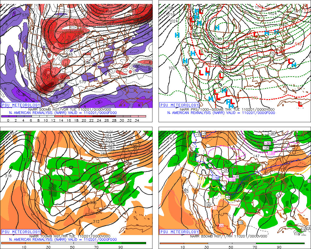
Interesting. I wish there was a way to dig up an archive of storms with maps revealing how they took shape. I know history likes to repeat itself pertaining to weather overall (especially in the winter). Thanks for clarifying. There is. The problem is you have to know the date to look it up, lol. Feb 2011 perhaps? <<http://voices.washingtonpost.com/capitalweathergang/images/midwest-storm-020211.jpg>>   |
|
|
|
Post by jeffcobeeman on Jan 13, 2022 15:21:25 GMT -6
So... it might snow? Not counting my chickens till they hatch.
|
|
|
|
Post by BRTNWXMAN on Jan 13, 2022 15:25:27 GMT -6
There is. The problem is you have to know the date to look it up, lol. Feb 2011 perhaps? <<http://voices.washingtonpost.com/capitalweathergang/images/midwest-storm-020211.jpg>>   No, that was a classic Southern Low that ejected out of the 4 Corners region.  |
|
mccarthb
Junior Forecaster
  O'Fallon, MO - Outer Road near border of Dardenne Prarie
Posts: 443 
|
Post by mccarthb on Jan 13, 2022 15:30:32 GMT -6
Feb 2011 perhaps? <<http://voices.washingtonpost.com/capitalweathergang/images/midwest-storm-020211.jpg>>   No, that was a classic Southern Low that ejected out of the 4 Corners region.  I majored in MIS and my career is behind a computer but I can't figure out how to get a jpg to reflect on screen in this forum using PC  |
|
|
|
Post by BRTNWXMAN on Jan 13, 2022 15:34:21 GMT -6
No, that was a classic Southern Low that ejected out of the 4 Corners region.  I majored in MIS and my career is behind a computer but I can't figure out how to get a jpg to reflect on screen in this forum using PC  You have to upload to a server like Imgur and then C&P the link using the little picture tab. |
|
|
|
Post by Snowstorm920 on Jan 13, 2022 15:38:01 GMT -6
Imgur->Upload new post->Get Share Links->copy and paste the BB code link
That’s what I do to post pics on here
|
|
mccarthb
Junior Forecaster
  O'Fallon, MO - Outer Road near border of Dardenne Prarie
Posts: 443 
|
Post by mccarthb on Jan 13, 2022 15:38:03 GMT -6
I majored in MIS and my career is behind a computer but I can't figure out how to get a jpg to reflect on screen in this forum using PC  You have to upload to a server like Imgur and then C&P the link using the little picture tab. Ahh, makes sense. I'd rather upload from tapatalk lol. I'm determined to find this storm you're referring to. I'm on a mission. |
|
|
|
Post by jmg378s on Jan 13, 2022 15:39:15 GMT -6
You have to upload to a server like Imgur and then C&P the link using the little picture tab. Ahh, makes sense. I'd rather upload from tapatalk lol. I'm determined to find this storm you're referring to. I'm on a mission. If you figure out the date you can go here to find charts: www.spc.noaa.gov/exper/ma_archive/ |
|